

Major rain storm moving through town
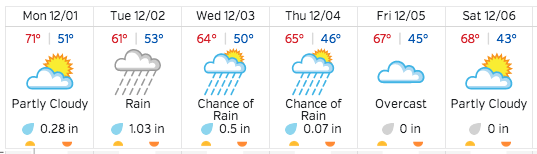 A Pacific storm dropped much-needed rainfall over Paso Robles Sunday with about a quarter-inch falling, according to weatherunderground.com. Much more rain is expected this week with as much as two inches expected. Look for the storm to begin early Tuesday morning and carry on through Thursday afternoon. Since the beginning of the rainfall season July 1, Paso Robles has received 1.03 inches. The average season yields about 14 inches, but the last two years fell short of the average. The 2013-14 season had 6.13 inches and the 2012-13 season had 7.18 inches of rainfall, according to city records.
The Pacific storm system is expected to bring significant rain to much of southwestern California this week, according to a special advisory from NOAA.
NOAA special advisory:
A strong upper level low pressure system will continue to develop in the eastern Pacific…then slowly approach the West Coast through Tuesday. This storm has the potential to bring a period of heavy rainfall to much of southwest California Tuesday into Tuesday evening.
There is a chance that rain could develop across much of the region late Monday night. The strong upper low will begin to approach the West Coast on Tuesday. Strengthening south to southwesterly flow aloft ahead of this storm is expected to tap into a rich subtropical moisture source well off the coast of Mexico…increasing the potential for heavy rainfall.
While there is still some uncertainty with respect to the exact timing of the heaviest rain and the ultimate rainfall totals…the potential exists for 1 to 2 inches of rain in coastal and valley areas…with 2 to 5 inches in the foothills and mountains. The one main concern at this point is the amount of low level easterly flow that could develop on Tuesday which could help to diminish the earlier rainfall estimates. It appears that rain will become most widespread and heaviest on Tuesday…lingering across Los Angeles County on Tuesday evening.
There is the potential of a 2 to 3 hour burst of heavy rainfall with this system on Tuesday…where rainfall rates around one half inch per hour will be possible. Rainfall rates of this intensity could bring the threat of flash flooding and mud and debris flows to locations in and around recent burn areas. As we draw closer to the event…a Flash Flood Watch may need to be issued for the recent burn areas. Additional rock and mudslides will also be possible in non-burn areas…especially along Highway 1 and canyon roads in the Santa Monica Mountains.
Other potential impacts from this storm system include gusty southeast to south winds on Tuesday…especially across higher terrain where gusts over 50 mph will be possible. The subtropical nature of this moisture will likely keep snow levels very high…generally above 7500 feet through at least Tuesday night. Scattered showers behind the main front will likely linger into Wednesday or Wednesday night…and snow levels would lower some at that time.