

Rain storm rolling in
Paso Robles weather forecast – Source: wunderground.com
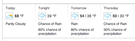
A cold storm system will bring rain and mountain snow to southwestern California Wednesday through Thursday.
A very cold storm system originating in the Gulf of Alaska will rapidly approach the California coast tonight. This storm will bring a period of steady rain to southwestern California… mainly Wednesday afternoon and evening across San Luis Obispo and Santa Barbara counties… and Wednesday night across Ventura and Los Angeles counties.
Behind the band of steady rain… there will be widespread rain showers and mountain snow showers Wednesday night and Thursday.
There is a slight chance of thunderstorms on Thursday… some of which could produce small hail. Showers will diminish late Thursday
and Thursday night.
Rainfall totals for this event are expected to average one quarter to one half inch in coastal and valley areas… one half inch to one
inch in the foothills and mountains… and one third of an inch or less in the deserts. Locally higher totals are possible in locations
that receive thunderstorms.
With this system… snow levels will fall to the lowest levels of the season so far… starting out around 6000 feet Wednesday afternoon…
then dropping to around 3500 feet by Thursday morning… and possibly as low as 3000 feet in heavier showers and thunderstorms. Snowfall totals late Wednesday through Thursday evening are expected to average 4 to 8 inches at elevations above 5000 feet… with 1 to 4
inches between 4000 and 5000 feet. Local totals up to one foot are possible at the highest elevations. A dusting of snow may fall at
elevations as low as 3500 feet… possibly even in the foothills above the Antelope and Cuyama valleys.
Potential impacts include snowfall on roadways into or through the mountains such as Interstate 5 over the Grapevine late Wednesday
night into Thursday. Accumulating snow is likely to produce hazardous driving conditions at times. Gusty winds combined with
moderate rain or snowfall may cause reduced visibilities at times.
Daytime temperatures will be 10 to 20 degrees below normal on Thursday. The combination of wet snow and low temperatures in the
mountains could easily create a dangerous situation for campers and outdoor enthusiasts that are not prepared for the change in the
weather conditions.
Source: National Weather Service