

County delays redrawing groundwater basin boundaries

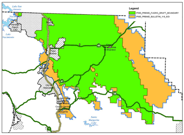
- Proposed new boundaries of the Paso Robles Groundwater Basin District. Green areas are the proposed district. Yellow areas represent the original boundaries defined by the the State of California.
County will let the courts decide
–Plans to redraw the boundaries for the proposed Paso Robles Groundwater Basin District were setback in December when the county announced the intention to wait for a determination from a January court hearing. Public Works Utilities Division Staff Engineer Courtney Howard confirmed that changing the boundaries has been postponed until after a court case hearing in January. Howard said those results will give the county better information for establishing the proposed district. The boundaries of the groundwater basin can only be changed by the State of California upon request from the county. The announcement was made by Carolyn Berg from the San Luis Obispo County Public Works Department during a Paso Robles Groundwater Basin Advisory Committee meeting.
In November 2013 a Quiet Title Lawsuit was filed by Plaintiffs Protect our Water Rights (POWR). The County of San Luis Obispo, the cities of Paso Robles and Atascadero and the San Miguel and Templeton Water Districts were named as defendants. The lawsuit claims that the county supervisors exceeded their legal authority by attempting to restrict the primary water rights of overlying users while at the same time exempting water purveyors who have inferior water rights. The courts handed the plaintiffs one victory in August of this year. The case is proceeding with another hearing set for January 2016.
Whether or not to establish the Paso Robles Groundwater Basin is set to be determined by a vote of landowners on March 8. The Paso Robles basin is actually designated as sub-basin 3-4.06 of the larger 3-4 Salinas Valley Groundwater Basin. The Salinas Valley aquifer runs from northern San Luis Obispo County through the Salinas Valley, continuing north and west past Salinas, borders the Monterey Bay and ends a few miles south of the Santa Cruz/Monterey County line.
The Paso Robles Groundwater sub-basin is the largest section of the nearly 1,000 square mile aquifer. One proposal from the advisory committee is to reduce the sub-basin boundaries by around 20-percent. The reduced boundary is based on a 2002 study that modifies the basin boundaries established by the California Department of Water Resources (DWR) Bulletin-118. The reduced boundary is derived from a ground water study by the Fugro corporation that was commissioned by the county. Fugro is an international company specializing in geotechnical, surveying, subsea and geoscience services.
In February 2016 ballots are being mailed to landowners and registered voters who live within the proposed boundary, excluding residents receiving water from municipal sources, such as residents in Atascadero, Paso Robles, and Templeton.
The ballots need to be returned to be counted on March 8. County Clerk Tommy Gong stated that approximately 7154 ballots are being mailed, 5,000 to landowners and 2154 to registered voters who are not landowners. Gong stated these numbers are “preliminary because the assessor’s office is still identifying landowners and registered voters within the proposed boundaries.” Gong also stated that the only way for the election to be canceled would be by court order.
There are three issues up for vote:
- Measure B-16: A vote to determine whether or not to create the Paso Robles Ground Water District. Only landowners get to vote on this issue and only get one vote. Measure B-16 requires a yes vote from 50-percent +1 of the returned ballots in order to pass.
- Measure A-16: A vote to determine whether or not to levy an assessment tax on landowners to fund the district. Only registered voters get to vote on this. If this measure passes by a two-thirds majority the tax is levied on landowners whether Measure B-16 passes or not. This tax is to collect more than $900,000 in new taxes for managing the Paso Robles Groundwater Basin.
- An election for a board of directors for the district. There are nine seats on the district board. Only five are open for election. Four directors will be appointed because those seats are not contested. Registered voters get to vote for three of the directors. Landowners get to vote for the remaining directors. The board of directors is not formed if Measure B-16 is defeated.
Preliminary election information, including candidates for the Board of Directors, can be viewed here.
Monterey County is represented on the Paso Robles Groundwater Basin Advisory Committee. A representative from Monterey County was not currently available for comment. Monterey County has had a role in the North County water supply since the Nacimiento Lake was created in 1956. Water is supplied to the lake by the Nacimiento River in South Monterey County. The lake was created primarily to recharge groundwater in Monterey County. San Luis Obispo County retained the rights to 17,500 acre feet of water per year. In October 2007, construction started on a pipeline to bring water from the lake to Paso Robles, Templeton, Atascadero, and San Luis Obispo.