

Major rain storm heading over Paso Robles
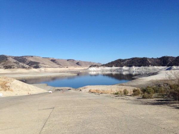
In need of rain: Lake San Antonio looks more like a pond this week at about 3-percent capacity. Photo by Tom Seidel.
After over a year of dry conditions and above average temperatures, wet weather is finally in the forecast for Paso Robles and the west coast, the Weather Channel reports.
Over the next several days, a dip in the jet stream will set up over the eastern Pacific Ocean, pushing moisture into California, Oregon and Washington. Two different storm systems are expected to develop over the Pacific Ocean and drench the west coast later this week, providing the parched region with beneficial rainfall.
The first storm is expected to roll in Wednesday night. Rain showers are forecasted through Saturday. As much as two inches of rain may fall on Paso Robles this week.
Summary forecast from wunderground.com
- Wednesday – Cloudy early with showers for the afternoon hours. High 66F. Winds S at 10 to 20 mph. Chance of rain 70%.
- Wednesday Night – Cloudy with periods of rain. Areas of fog developing late. Low near 50F. Winds SSW at 10 to 20 mph. Chance of rain 80%. Rainfall near a quarter of an inch.
- Thursday- Sunshine and clouds mixed. High 66F. Winds SSW at 5 to 10 mph.
- Thursday Night – Cloudy skies with periods of rain after midnight. Low 48F. Winds SE at 10 to 15 mph. Rainfall near a half an inch.
- Friday – Rain with a few thunderstorms likely. High 57F. Winds S at 15 to 25 mph.
- Friday Night – Steady light rain in the evening. Showers continuing late. Low 46F. Winds S at 10 to 20 mph. Chance of rain 80%.
- Saturday – Cloudy with a few showers. High 64F. Winds SE at 10 to 15 mph. Chance of rain 30%.