

South River Road reopens after 4-day closure

Paso Robles sunset on Thursday evening. Photo by Christine Brennan.
Due to the weather forecast, roadways may close again over the weekend
– South River Road was open this morning between 13th Street and Navajo Avenue. The stretch of road has been closed since Monday after rainstorms caused mudslides onto the roadway. City crews worked with heavy equipment the last few days to clear the debris.
North River Road remains closed between River Oaks Dr. and the county line, but all other roads are currently open. Cleanup work will continue on roadways throughout the city. Due to the weather forecast, roadways may close again over the weekend.
Also reopened is 21st Street between Pine Street and Riverside Avenue, and Vine Street between 22nd and 24th streets.
The Paso Robles City Council met Thursday night to formally declare a local emergency. This move should help local residents apply for aid from the Federal Emergency Management Agency.
Residents are strongly encouraged to report home and property damage to the County Office of Emergency Services to provide to FEMA via a form on ReadySLO.org. A countywide dollar amount threshold must be met before residents are eligible for financial recovery assistance. If assistance becomes available, homeowners will be notified.
Complete this form to report damage sustained to your private property. There is no guarantee that FEMA funding will come available, but we need your reports to try and receive funding.
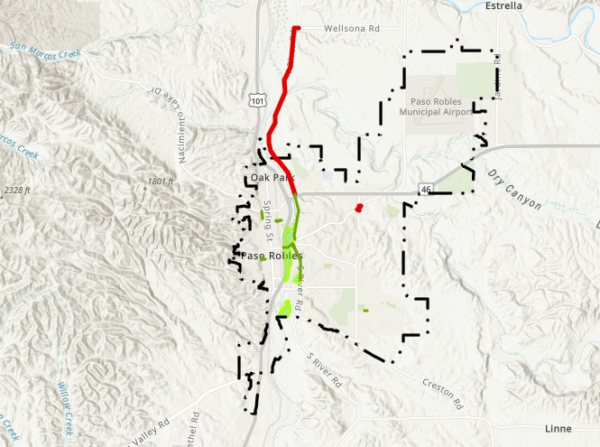
Current city road closures as of 8 a.m.
Click here to view current city road closures.
For current county road closures, go to: https://www.slocounty.ca.gov/Departments/Public-Works/Services/Maps/Road-Closures-and-Delays.aspx
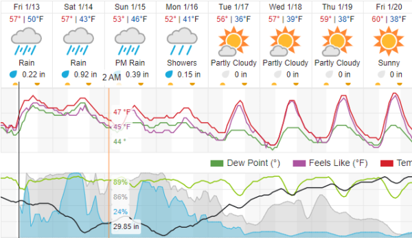
Rain showers are expected to begin again today in the late morning and continue through Tuesday. Click here to view a 10-day forecast for Paso Robles.
The city has made sand available for anyone wishing to make sandbags to protect private property. Sand can be found at the City Streets Yard located at 1220 Paso Robles Street. A shovel is onsite, but please bring your own sandbags as they are not available on-site. Lists of locations to buy sandbags are available on ReadySLO.org.
All residents living in an area prone to flooding should have a plan in place on where they will go if they need to evacuate. Remember to plan for pets and any medication or items you need to bring with you.
It is strongly advised to avoid driving through, entering, or playing in moving water at all times. During major storm events, public safety resources are in high demand. Avoiding situations that may require an emergency response is a priority.
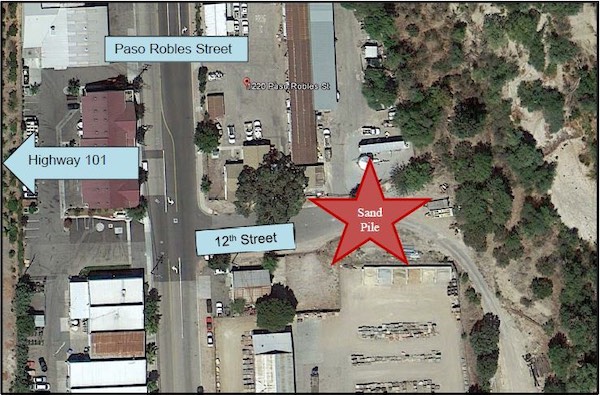
The city has made sand available for anyone wishing to make sandbags to protect private property. Sand can be found at the City Streets Yard located at 1220 Paso Robles Street.
‘Live stream’ observed in Salinas River
The County of San Luis Obispo Public Works Department reports that it observed visible surface water flow (commonly referred to as a “live stream”) in the Salinas River between the Salinas Reservoir Dam (Santa Margarita Lake) located in the community of Santa Margarita to the Nacimiento River junction, located just north of the San Luis Obispo County line. The Salinas Reservoir serves as one of four primary water supply sources for the City of San Luis Obispo.
Under the provisions of the 1972 Live-Stream ruling by the State Water Resources Control Board, total inflow to the reservoir is released downstream until a live stream is observed in the Salinas River. The release is a provision of the ruling to protect downstream water rights.
Recent rainfall has created a natural live-stream flow in the Salinas River, therefore, the total inflow to the reservoir may be stored.
“This season’s rainfall has completely filled the reservoir and water is spilling over the dam downstream,” says County Public Works Water Systems Superintendent Kyle James.
When the live stream no longer exists, the county will resume releasing water from the reservoir to the Salinas River.
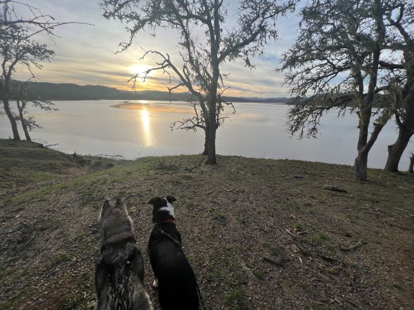
Local pups look over a full Lake Nacimiento Thursday evening in North County. Photo by Marc Coons.
Local lake, river levels
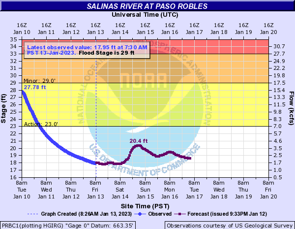
The Salinas River level has dropped to 18.6 feet as of this morning, according to the National Weather Service. Measurements are taken from the 13th Street bridge. Click here to view current levels.
Lake Nacimiento is at 75% capacity as of Thursday morning. A week ago it was at 34%. Lake San Antonio rose from 12% to 26% over the same period. Click here to view current local lake levels.
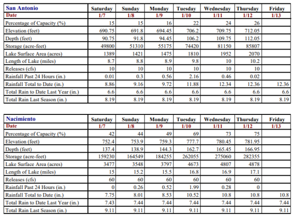
Lake levels as of Friday morning.
Related:
Update: Approximately 200 personnel continue searching for Kyle Doan
Sewage released into Salinas River