

Growing network of weather stations, fire-watch cameras help provide hyperlocal data
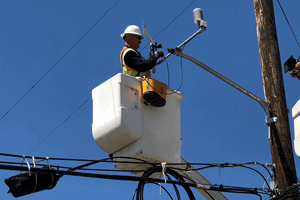
A worker installs a weather station. Photo from PG&E.
–In 2020, 400 new weather stations brought Pacific Gas and Electric Company’s (PG&E) network total to 1,000 installed and operational cameras, and the number of high-definition cameras more than doubled with over 300 in operation. PG&E’s expanded network of enhanced weather technology, including weather stations and high-definition fire-watch cameras located in areas of elevated or extreme fire risk, reportedly helped reduce the size of each Public Safety Power Shutoff (PSPS) event in 2020 on average by 55-percent.
As of the end of year, PG&E had 1,000 weather stations and 340 cameras in operation throughout Northern and Central California, providing more precise weather data to the company’s team of meteorologists and outside agencies. The weather stations, along with sectionalizing devices that isolate the grid into smaller segments and deployment of temporary generation and microgrids, enabled PG&E to keep the lights on for thousands of customers who would have lost power during comparable weather events in 2019. Due to these advancements, PG&E removed more than 800,000 customers from scope during 2020 PSPS events.
In 2020, PG&E installed 400 new weather stations and 216 HD cameras as part of its Community Wildfire Safety Program. These high-tech tools provide better situational awareness and more precise weather monitoring and forecasting that allowed for more precision in determining where a PSPS is needed.
“As a real-time situational awareness tool, we’re able to use our high-density weather observation network at the start of a PSPS event to assess if forecasted critical fire weather conditions are materializing or not,” said PG&E Senior Meteorologist Ashley Helmetag. “In a PSPS event, if the conditions are not materializing above risk thresholds, then we’re able to use this data as one of our decision-making support tools to significantly shrink or eliminate an area that was originally in scope for power shut off.”
In addition to PG&E’s in-house meteorology team, the expert staff in the company’s Wildfire Safety Operations Center (WSOC) rely on this real-time information, as well as outside agencies and first-responders as they make critical decisions during wildfire season.
“We are working every day to improve the safety of our electric system and reduce wildfire risks,” said PG&E’s interim head of Electric Operations Debbie Powell. “In addition to preventing wildfires, our focus is on improving weather awareness and reducing the impact of public safety power outages on customers and communities. Our growing network of weather stations and high-definition cameras helps PG&E meteorologists and analysts do just that.”
PG&E has been adding to its network of weather stations and cameras since 2018, mostly in high fire-threat areas in Northern and Central California. The program, which plans to install 1,300 weather stations by the end of 2021, is designed to create a density of roughly one weather station for every 20 miles of electric lines in high fire-threat areas. By the end of 2022, PG&E plans to have nearly 600 cameras installed. When complete, PG&E says they expect to have the ability to see in real-time roughly 90-percent of the high fire-risk areas it serves.
The stations provide temperature, wind speed, and humidity data that is monitored, tracked and evaluated by PG&E’s meteorology team and analysts in the WSOC. The WSOC is the hub from which PG&E detects, evaluates and monitors wildfire threats across its service area. It’s also where the company instigates responses to those threats and a center for coordination with first responders and public safety officials. Weather station observations are available to state and local agencies as well as the public, through PG&E’s website at www.pge.com/weather and through MesoWest.
The WSOC staff also use PG&E’s network of fire-watch cameras to monitor and respond to wildfires. These resources are also available to CAL FIRE and other fire agencies, as needed, and can be viewed publicly by anyone through the Alert Wildfire Network at www.alertwildfire.org.
For more information about PG&E’s wildfire mitigations and efforts to reduce the impacts of PSPS events, visit pge.com/wildfiresafety.