County supervisors re-classify ground water ‘red zones’ with new data
–This week, the San Luis Obispo County Board of Supervisors modified “red zones” for water management in the North County.
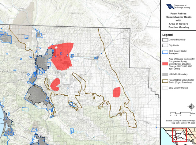
The red zone is defined as any property which has experienced a 50-foot drop in well-water elevation levels over the years from spring 1997 to spring 2013, or spring 1997 to spring 2017. People moving out of red zone restrictions will only be allowed to use five-acre feet of water. That’s enough water to operate a small farm. Each free-standing house uses an average of 2.5 acre-feet of water.
Because of new data on water levels, the county removed 37,000 acres from the red zone. Another 25,000 other acres were placed in the red zone because they’re experiencing a severe decline in their water levels.
Utilizing information developed by monitoring wells, the county is working to protect the Paso Robles Groundwater Basin.
Supervisor John Peschong says well water levels may vary dramatically in different areas of the North County. For instance, one property owner in San Miguel notified the county he had been placed in a red zone, but his water levels have stayed consistent for more than 20 years. So, his property was reclassified and removed from the red zone.
A few months ago, the county flew a helicopter over the area to accumulate more data for the mapping of the groundwater basin. That information helps the county to make changes when appropriate to protect the groundwater basin.
Peschong says, “We do not allow additional mass amounts of pumping. People should not see their wells drop overnight because of some new agricultural operation in the North County.”
Supervisor Peschong encourages people to contact him if they experience a severe decline in water levels.
An urgency ordinance is still in place to prevent people from expanding their operations and using massive amounts of water in the basin while the state processes the county water plan. That ordinance will continue to govern water use while the county water plan slowly makes its way through the state approval process.
The vote to alter the red zones passed 3-1 with Supervisor Bruce Gibson casting the lone dissenting vote. The former oil company geologist objected to changes in the red zone because he fears it will facilitate major water pumping from the aquifer. Supervisor Debbie Arnold said that any increase would be minimal because of the five-acre feet restriction.
“Once we had updated data to show that a good portion of the area of severe decline was not showing severe declines in well levels we voted to take them out of that designation,” explained Arnold. “We want our land-use policies to be based on the best data available. Many of the historical farming families in the North County stopped irrigating during the drought and were denied their ability to resume irrigated farming after the drought. At the same time, many large irrigators that continued to plant during the drought years were allowed to continue. While this change in the area of severe decline boundaries acknowledges that some properties should not have been included in that area of severe decline, it still does not give those properties the ability to resume their historical irrigating practices. It will allow property owners who were erroneously put into the area of severe decline to have the ability to pump 5-acre feet of water annually on their farm the same as other rural properties in the larger basin.”
San Luis Obispo County Department of Planning and Building oversees the Paso Robles Groundwater Basin.
Click here for current Paso Robles Groundwater Basin maps from the county


