
Public lands in San Luis Obispo County could be opened to drilling, fracking
BLM accepting public comments until Sept. 7
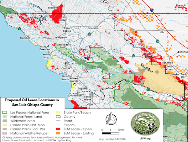
–The Trump Administration is seeking to open more than 123,000 acres of federal land and mineral estate in the county to fracking and oil drilling, according to an analysis of official GIS data performed by the local nonprofit watchdog organization Los Padres ForestWatch.
The areas slated for drilling are part of a regional study – launched earlier this month – evaluating the environmental and public health impacts of fracking across 1.6 million acres in six counties in central California. The 30-day public comment period ends on Sept. 7.
The study could open several key parcels in San Luis Obispo County to drilling and fracking, including:
City of San Luis Obispo & Irish Hills Natural Reserve – The BLM plan would open a 200-acre parcel just east of the City of San Luis Obispo to drilling and fracking. Much of it overlaps with the City of San Luis Obispo’s Reservoir Canyon Nature Reserve, where BLM mineral rights underlie a popular loop trail with panoramic views of the city and the Santa Lucia Mountains. Also, on Mine Hill southwest of the city limits, the plan would open a 76-acre BLM-owned parcel to drilling and fracking. This parcel is directly adjacent to the Irish Hills Natural Reserve, a 720-acre open space administered by the City of San Luis Obispo with many popular trails.
Cayucos & Whale Rock Reservoir – The BLM plan opens 980 acres of BLM land upstream from Whale Rock Reservoir and adjacent to the Los Padres National Forest. Whale Rock Reservoir serves as a source of clean drinking water for the City of San Luis Obispo and the Cal Poly campus. The City and the California Conservation Corps have also embarked on a multi-year effort here to eradicate invasive fish from the reservoir and restore steelhead that historically spawned in the area. The reservoir is popular with hikers, anglers, picnicking families, and bird watchers who flock to the area to view the reservoir’s resident bald eagles, osprey, and migratory birds.
Los Osos Middle School – The BLM plan would open a 5-acre parcel to drilling and fracking directly across the street from Los Osos Middle School and within 300 feet of the southern boundary of Morro Bay State Park.
Montana de Oro State Park – The BLM plan would open 1,222 acres of federally-owned mineral estate within Montana de Oro State Park, a coastal park popular with hikers, mountain bikers, equestrians, campers, and beach visitors. The area slated for drilling and fracking covers nearly the entire southeastern corner of the park, including the popular Alan Peak Trail between Alan Peak and Oats Peak. The surface is owned and managed by California State Parks, but the underlying mineral rights are held by BLM.
Carrizo Plains Ecological Reserve – The Carrizo Plains Ecological Reserve is a 38,900-acre wildlife preserve that connects the Los Padres National Forest to the Carrizo Plain National Monument, and is owned and managed by the California Department of Fish & Wildlife. However, BLM owns portions of the mineral rights underlying the area. The BLM plan would open nearly one-third of the reserve (12,802 acres) to oil drilling and fracking, threatening several endangered species along with native grasslands, vernal pools, and reintroduced populations of tule elk and pronghorn antelope. Several hiking and equestrian trails pass through the lands slated for drilling.
Carrizo Plain National Monument – While the BLM’s plan does not address drilling and fracking inside the Carrizo Plain National Monument (that area has its own separate management plan), it would allow drilling and fracking across 15,338 acres directly adjacent to the monument’s eastern boundary in the Temblor Mountains.
Machesna Mountain Wilderness – The plan would open 480 acres of private land immediately adjacent to the Machesna Mountain Wilderness in the Los Padres National Forest. The wilderness area was established by Congress in 1984.
Huasna Valley – The BLM plan would open nearly 2,500 acres in the Huasna Valley and surrounding foothills to drilling and fracking. Included among them are several parcels alongside Huasna Road, one of the key gateways into the Los Padres National Forest.
Lopez Lake – The BLM plan would open a 4-acre parcel on the shore of Lopez Lake near the Dune Vista Trail, along with another 320 acres on a hillside a half-mile away that drains directly into the lake. These are mostly state-owned lands with BLM sub-surface mineral estate. The lake provides clean drinking water to the Five Cities and includes a popular recreation area administered by San Luis Obispo County Parks offering camping, fishing, boating, picnicking, hiking and equestrian trails, mountain biking, zip-lining, and birdwatching.
Morro Rock – The BLM plan identifies Morro Rock, a volcanic plug at the entrance to Morro Bay Harbor, as an area open to drilling and fracking. It is protected as the Morro Rock State Preserve and is a State Historic Landmark.
Santa Margarita Lake, Park Hill, and Calf Canyon Along Highway 58 – The BLM plan would open scattered parcels in the area bounded by Santa Margarita, Highway 58, and Santa Margarita Lake totaling more than 5,000 acres of mostly BLM-owned land. It includes several large parcels bordering and emptying into Santa Margarita Lake, which provides clean drinking water for the City of San Luis Obispo along with numerous outdoor recreation opportunities.
La Panza Mountain Range – The BLM plan would open more than 7,000 acres to drilling and fracking on BLM land in the La Panza Mountain Range along the San Juan River, between Los Padres National Forest and Carrizo Plain National Monument.
Camp Roberts – The BLM plan would open more than 43,000 acres of Camp Roberts, a California National Guard post where units train annually. The national guard also opens these vast lands to the public for hunting and fishing opportunities.
Lake Nacimiento & Santa Lucia Range – The BLM plan opens more than 32,000 acres of parcels in the Santa Lucia Mountains between Highway 46 and the SLO-Monterey county line, including hundreds of acres surrounding Lake Nacimiento. Some of these parcels are visible along Highway 1 near Pine Top Mountain at the gateway to the Big Sur coastline.
Some of these lands are owned by BLM, while others are known as “split estate” parcels because the BLM only owns the underlying mineral rights (and not the surface, which is owned by a private landowner). For these split-estate parcels, the BLM did not directly notify the overlying surface owners of the public comment period that is currently underway, and many were unaware of it until ForestWatch requested the data from BLM, analyzed it using mapping software, and notified the landowners.
Under federal law, once its study is complete, the BLM can auction off the drilling rights to these parcels for as little as $2.00 per acre, possibly giving oil companies the right to construct roads, oil wells, pipelines, and other infrastructure on these privately-owned parcels.
“This plan is a direct attack on some of the most iconic landmarks in Ventura County,” said ForestWatch executive director Jeff Kuyper. “Drilling and fracking would irreparably change these places that have been set aside for their outdoor recreation opportunities, wildlife habitat, and scenic views.”
ForestWatch has posted the BLM’s GIS data on an easy-to-use interactive map showing the parcels open for drilling and fracking. Numerous requests from conservation groups prompted BLM to make the information publicly available during the comment period.
The BLM is accepting comments on its study of drilling and fracking until Sept. 7. The public can submit comments to BLM via an easy online portal at www.LPFW.org/fracking or directly through the BLM’s website.
“Residents throughout San Luis Obispo County are concerned about the impacts of drilling and fracking near our region’s most treasured forests, wildlife refuges, national monuments, nature preserves, and trails,” said Kuyper. “We need to tell the Trump Administration loud and clear that we’re not willing to pollute and industrialize these iconic landscapes.”