
Series of storms to pass through North County this week
–A series of storm systems are lining up across the Pacific Ocean and will affect southwest California through the week. Rainfall is expected most days this week, according to Weather Underground.
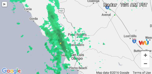
Weather radar as of 7:30 a.m. Monday morning shows the first storm in the series expected in the next week.
The first storm was expected to bring rain to the Central Coast by Sunday afternoon spreading south of Point Conception on Sunday night. The chance of rain and mountain snow is expected to persist across the entire forecast area Monday. There is still some uncertainty on rainfall amounts with this first system, according to Weather Underground, but most areas should see between one quarter and three quarters of an Inch.
The second storm on Tuesday is forecasted to be stronger with more southerly flow that will help to enhance rainfall totals, especially across south facing mountains and foothills. Coastal and valley areas can generally expect between one and two inches of rain with this system, with two to four inches possible in the foothills and mountains.
Due to the potential for rainfall rates briefly reaching one half inch per hour, recent burn areas will be at risk for flash flooding with mud and debris flows.
Periods of additional rain and mountain snow will be likely Wednesday through Friday. There is still some uncertainty in the exact timing and track of these systems later in the week, however the potential exists for brief heavy downpours and isolated thunderstorms.
On top of the rain and snow there will be high surf conditions much of next week potentially reaching damaging levels by Wednesday or Thursday. The combination of high surf gusty winds periods of rain and high tides will bring the potential for some coastal flooding by midweek.
The public is advised to finish up outdoor projects and consider preparing sand bags for possible flooding and debris flows. Residents with beachfront property are advised to monitor the latest forecasts, watches, warnings, and advisories as the storms and swells move closer to the region. Travelers and motorists should monitor the latest forecasts and are advised to make contingency travel plans especially on Tuesday and Wednesday when the heaviest rain and snow arrive. Local commutes could be impacted due to possible roadway flooding on pavement surfaces.
City providing sand for sandbags
–The city has sand available for sandbags at the City Streets Yard located at 1220 Paso Robles Street. Please make sure to bring a shovel.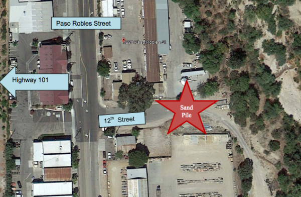
Empty sand bags are available for purchase at the following locations:
- American Builders Supply 1108 Paso Robles St. (805) 239-4317
- Lowe’s 2445 Golden Hill Road (805) 602-9051
- Blake’s Hardware 1701 Riverside Avenue (805) 238-3934
- OSH (Orchard) 2505 Theatre Drive (805) 226-0604
- Farm Supply 2450 Ramada Drive (805) 238-1177