Storm update: Road closures, river level, lake levels
– Heavy rain is in the forecast for today for Paso Robles. Weather Underground currently predicts .67 inches today, light rain on Sunday, and .22 inches on Monday. The season total for rainfall in the city is 16.07 inches. That is higher than the season average of 14.21 inches since 1942.
Wind advisory
The National Weather Service has issued a wind advisory in effect for San Luis Obispo County from noon until 9 p.m. tonight. Areas under advisory include San Luis Obispo County Interior Valleys – and Hearst Castle, Irish Hills, Atascadero, Lake Nacimiento, Paso Robles, San Miguel, Templeton, Carrizo Plain, Creston, and Shandon.
Expect southwest winds of 20 to 35 mph with gusts of 40 to 50 mph. Strongest winds are expected across higher terrain and Carrizo Plain.
Roads update
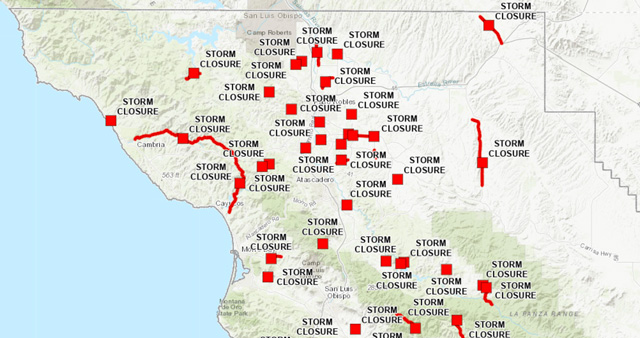
Numerous roads and bridges remained closed throughout San Luis Obispo County. See the county’s updated map here for details.
Most roads in the city limits of Paso Robles were open on Saturday morning, though North River Road from Union to Wellsona roads remains closed. See the city’s updated map here for details.
Salinas River level
The Salinas River level has dropped from 18.6 feet to 17.3 feet overnight, according to the National Weather Service. Measurements of the river are taken near the 13th Street Bridge. Click here to view current levels.
Lake levels
Lake Nacimiento is at 76% capacity and Lake San Antonio is at 27% capacity as of Friday. Click here to view current local lake levels.
A 990 mb low will be centered over San Francisco on Sunday. The associated front will produce 32 to 46 mph with gusts to 55 mph southerly winds and moderate rain with a chance of thunderstorms as it moves through the Central Coast on Martin Luther King Jr. Day. #CAwx????️????️⛈️ pic.twitter.com/1dEFZgrGMc
— John Lindsey (@PGE_John) January 13, 2023
Comments
The news staff of the Paso Robles Daily News wrote or edited this story from local contributors and press releases. The news staff can be reached at info@pasoroblesdailynews.com.


