
Over 2-inches of rain and flooding cause mayhem in Paso Robles

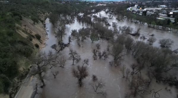
The Salinas River level rises as seen in this aerial photo of the Highway 46 East and Highway 101 interchange. Photo by Damien Marquez.
Total of 2.48 inches of rain has been recorded in the past 24 hours
– North County joins the rest of the state and the entire region in being inundated with rain over the past few days. An extreme amount of rainfall has wreaked havoc across the county.
Today’s forecast should bring just .06-inches of rain to Paso Robles, with a break in storms starting this evening until Friday, when another storm system will pass through the area, according to weather forecasts. Additional adverse weather is expected late this week through next weekend.
Click here to view a 10-day forecast for Paso Robles.
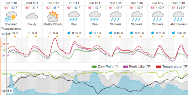
A total of 2.48 inches of rain has been recorded in Paso Robles in the past 24 hours. The current season total is 15.74 inches. Click here to view the Paso Robles Rainfall Totals page.
Near Paso Robles, a five-year-old child was swept away in flood waters. The search was later halted due to unsafe conditions. Click here to view a full report on the incident.
County-wide, mudslides have damaged homes in Los Osos, and one person is confirmed dead after water overtook their vehicle in Avila Beach. Additional reports of damage are still coming in.
A mudslide closes South River Road. Photo by Damian Marquez.
Road closures
Road closure information according to multiple reports as of 7 a.m. Tuesday:
Creston Road was closed due to flooding on Monday morning.
Paso Robles
- Northbound and southbound Highway 101 in Paso Robles
- San Marcos Road to HWY 101 to Nacimiento Lake Road since Tuesday at 12:16 a.m.
- Adelaida Road to Vineyard Drive to Nacimiento Lake Drive since Monday at 8:39 p.m.
- Adelaida Road to Chimney Rock Road to Vineyard Drive since Monday at 9:06 p.m.
- Chimney Rock Road since Tuesday at 4:08 a.m.
- Peachy Canyon Road since Monday at 9:18 p.m.
- South River Road to Spanish Camp Road since Monday at 11:58 p.m.
- Highway 101 at 17th Street since Monday at 3:47 a.m.
- 13th Street Bridge since Monday at 4:04 p.m.
- Creston Road to Neal Spring Road to Cripple Creek Road since Tuesday at 1:47 a.m.
- 13th St Bridge between South River Rd and Riverside Ave. – closed as of 8 a.m.
- N. River Rd (Union to Monterey Co. Line) – closed as of 8 a.m.
- S. River between 13th St. and Navajo – closed as of 8 a.m.
- Vine St from 22nd to 24th St remains – closed as of 8 a.m.
A portion of Commerce Way was flooded on Monday morning.
Atascadero
- Southbound El Camino Real at San Rafael
- Southbound at El Camino Real at Viejo Camino to Santa Barbara
- Santa Barbara from El Camino Real at San Antonio Road (right by Hwy. 101), but still allows access to San Antonio
- San Gabriel at Hwy 41
- Portola at Hwy 41
- Carmelita at Piedras Altos
- Curbaril at Carmelita
- Southbound Hwy 101 offramp at Hwy 41
- Curbaril at Amapoa
- Amapoa from Curbaril to Portola
- Viejo Camino from El Camino Real to Santa Barbara
- Atascadero Avenue at Ortega
- Castano between Curbaril to Maleza
- Halcon River Crossing
- Via Bridge
- 6390 Flores – a tree has just been cleared
- Santa Cruz at Santa Ana
- 4900 Block of Traffic Way
Creston
- Redondo Lane since Monday at 9:32 p.m.
- O’Donovan Road closed since Tuesday at 2:23 a.m.
Templeton
- Salinas Avenue between Hawley Street and Eddy Street closed since Monday at 3:57 p.m.
- South El Pomar Road to Homestead Road to Rancho Road since Monday at 8:54 p.m.
Santa Margarita
- Tassajara Creek Road closed since Monday at 6:36 p.m.
- 4700 block of Las Pilitas Road since Monday at 7:50 p.m.
San Luis Obispo
- Buckley Road to Vachell Lane to Hoover Road since Monday at 7:27 p.m.
- South Higuera Street near HWY 101 closed since Monday at 8:45 p.m.
- Orcutt Road to Righetti Road to Avocado Lane closed since Tuesday at 3:22 a.m.
- Orcutt Road from Biddle Ranch Road to city limit since Tuesday at 5:20 a.m.
- Monte Road before Baron Canyon Ranch Road since Monday at 7:43 p.m.
San Simeon
- San Simeon Creek Road closed since Monday at 8:45 p.m.
Cambria
- Green Street to Ardath Drive closed since Monday at 9:13 p.m.
Morro Bay
- San Luisito Creek Road near Nicola Ranch Road closed since Monday at 11:35 p.m.
- South Bay Boulevard closed since Monday at 8:30 p.m.
- Turri Road closed since Monday at 8:32 p.m.

Current outages as of 8 a.m. Click here to view a current outage map.
Outages
Multiple power outages have been reported in the county, including large-scale outages in Atascadero, Avila Beach, and Nipomo, according to the PG&E outage map as of 7 a.m. Tuesday.
“In some portions of the service area, high winds, flooding, and soil instability issues have made it unsafe for crews to work, which may lead to extended outages for our customers,” wrote PG&E Communications Representative Carina Corral:
This is especially true for areas including Morro Bay, Cayucos, and Cambria and north of the Cuesta Grade where downed trees are the causes of many outages. Traffic jams because of flooded intersections and traffic lights being out are also causing gridlock in many areas and slowing our crews’ response.
We understand how important electricity is for our customers to keep themselves and their families safe, and we will continue working tirelessly to restore power. We appreciate our customers’ patience as we work to restore power.
As a reminder, community members should always assume downed power lines are energized and dangerous. Call 9-1-1 immediately to report the location of a downed line.
PG&E continues responding to the intense series of winter storms impacting Northern and Central California and has mobilized its largest storm response effort in company history.
PG&E has more than 5,000 dedicated personnel currently responding to the storm, including contractors and mutual aid from Southern California, Canada, Colorado, Idaho, New Mexico, Oregon, Utah, Washington, Wisconsin, and Wyoming, with additional resources expected to arrive and assist in the coming days. Hundreds of PG&E employees are serving in the company’s Emergency Operations Center as well as in regional and divisional emergency centers.
Click here to view a current outage map.
Water flowing at Oak Street and 23rd in Paso Robles. Photo by Richard Mason.
Evacuation and shelter information
The Paso Robles Department has placed multiple low-lying neighborhoods under evacuation orders. Click here to read a full story on current evacuations.
The American Red Cross Pacific Coast Chapter has opened five evacuation shelters due to flooding throughout San Luis Obispo, Santa Barbara, and Ventura Counties. Red Cross volunteers will provide safe shelter, water, meals, emotional support, health services, and additional resources to displaced evacuees.
Shelter location
-Paso Robles Event Center, Ponderosa Pavilion (2198 Riverside Ave, Paso Robles, CA 93446)
If they have time, evacuating residents are encouraged to bring the following for each member of their family: prescription and other emergency medication, extra clothing, pillows, blankets, hygiene supplies, important documents, and other comfort items. Additionally, special items for children and infants, such as diapers, formulas, and toys, should be brought along with other items for family members who may have other needs.
Red Cross shelters are open to everyone in need, regardless of race, religion, gender identity, sexual orientation or citizenshipstatus. All disaster assistance is free.
People can find information for open Red Cross and partner shelters on redcross.org/shelter, the free Red Cross Emergency app or by calling 1-800-RED CROSS (800-733-2767). Download the app by searching “American Red Cross” in your app store or by going to redcross.org/apps.
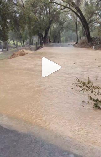
Local flooding photos and videos

Flooding in Atascadero. Photo by Rick Evans.

Flooding in Atascadero park. Photo by Rick Evans.
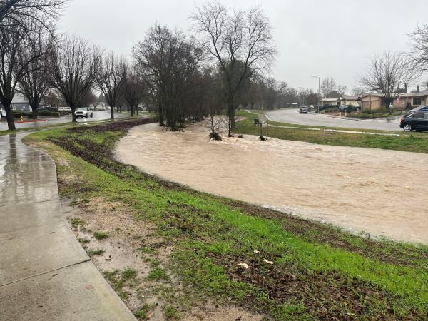
A full Turtle Creek in Paso Robles. Photo by Richard Mason.

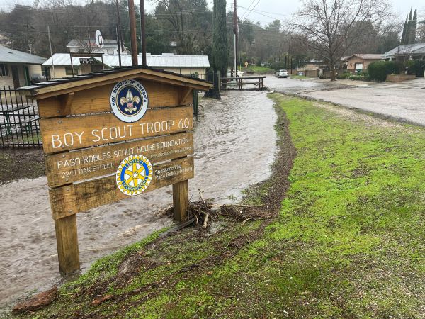
Flooding on Oak Street. Photo by Richard Mason.

Lake Nacimiento filling up.

The Salinas River and Niblick Bridge as of 8 a.m.
Related
- City activates emergency operations center as floodwaters rise on Monday
- Public is advised to avoid contact with flood waters
- 13th Street Bridge is closed as storm fills Salinas River
- Update: Flash flood warning downgraded to flood watch
- Update: Local schools closed due to weather